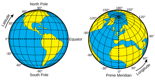
Angular coordinates: Latitude-Longitude
X,Y coordinates underpin all GIS work, as they encode the location information in all geospatial datasets. Here we explain Latitude-Longitude coordinates, also known as geographical or angular coordinates
- Angular coordinates
- The natural way to specify a location on the surface of a sphere is by using angles. Angular coordinates are the difference in degrees from a known reference point (0,0) to the location of interest
Latitude-Longitude
Latitude and longitude are angular coordinates, with a 0,0 reference point where the prime meridian (through Greenwich in London, England) and the equator intersect. Hanoi, the capital of Vietnam, is located at 21.03°N, 105.85°E, or roughly 21 degrees north of the equator and 105 degrees east of Greenwich

- Latitude
- Lines of latitude form circles drawn at even intervals around the earth, parallel with the equator. They are known as parallels. The equator is at 0° latitude, the south pole is at 90°S. The distance between parallels is identical everywhere on the earth’s surface: about 111km for every 1 degree of latitude
- Longitude
- Lines of longitude form semi-circles drawn between the poles, like the segments of an orange or the lines on a basketball
 They are called meridians. The prime meridian is drawn through Greenwich, east London, and other meridians are measured by their angle east or west of the prime meridian, from 180°W (near Hawaii) to 180°E (New Zealand). Meridians are not parallel; they converge at the poles. This means that the straight-line distance between two meridians depends on how close you are to the equator. For example. 1 degree of longitude is c. 110km at the equator, but only c. 42km at the Antarctic circle (66°30’S).
Note that when you state Latitude-Longitude coordinates, the ‘y’ coordinate (north/south = Latitude) comes before the ‘x’ coordinate (east/west = Longitude). This is for historic reasons - the ability to measure latitude from the position of the stars was developed long before people could accurately measure longitude because of the complication of the earth’s rotation

